


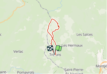
Lozere - Trelans sous le Mailhe-Biau 17km 459m

RandoVal
User

Length
16.9 km

Max alt
1416 m

Uphill gradient
487 m
Km-Effort
23 km

Min alt
951 m

Downhill gradient
484 m
Boucle
Yes
Creation date :
2018-09-12 19:08:56.02
Updated on :
2022-01-31 20:47:36.012
5h00
Difficulty : Difficult

FREE GPS app for hiking
 SityTrail
IGN / Geographical institutes
SityTrail Plus
The world is yours!
About
Trail Walking of 16.9 km to be discovered at Occitania, Lozère, Trélans. This trail is proposed by RandoVal.
Description
Boucle en Aubrac. Départ de Trélans sens anti-horaire. montée vers le Mailhe-Biau. Passage dans les patures, suivre la trace GPS.
Positioning
Country:
France
Region :
Occitania
Department/Province :
Lozère
Municipality :
Trélans
Location:
Unknown
Start:(Dec)
Start:(UTM)
507348 ; 4927439 (31T) N.
Comments