


Saint Julien sur Suran

drarep
User
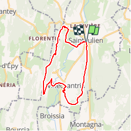

Length
13.3 km

Max alt
541 m

Uphill gradient
385 m
Km-Effort
18.5 km

Min alt
343 m

Downhill gradient
385 m
Boucle
Yes
Creation date :
2017-01-26 00:00:00.0
Updated on :
2018-12-20 21:54:11.428
3h08
Difficulty : Easy

FREE GPS app for hiking
 SityTrail
IGN / Geographical institutes
SityTrail Plus
The world is yours!
About
Trail Walking of 13.3 km to be discovered at Bourgogne-Franche-Comté, Jura, Val-Suran. This trail is proposed by drarep.
Positioning
Country:
France
Region :
Bourgogne-Franche-Comté
Department/Province :
Jura
Municipality :
Val-Suran
Location:
Unknown
Start:(Dec)
Start:(UTM)
688666 ; 5140753 (31T) N.
Comments