


la fontaine dartigues

babeth35
User
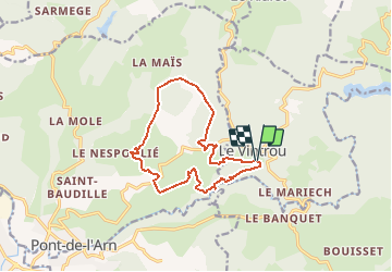

Length
13.5 km

Max alt
652 m

Uphill gradient
389 m
Km-Effort
18.7 km

Min alt
400 m

Downhill gradient
393 m
Boucle
Yes
Creation date :
2016-12-13 00:00:00.0
Updated on :
2020-07-20 15:25:56.383
--
Difficulty : Unknown

FREE GPS app for hiking
 SityTrail
IGN / Geographical institutes
SityTrail Plus
The world is yours!
About
Trail Walking of 13.5 km to be discovered at Occitania, Tarn, Le Vintrou. This trail is proposed by babeth35.
Positioning
Country:
France
Region :
Occitania
Department/Province :
Tarn
Municipality :
Le Vintrou
Location:
Unknown
Start:(Dec)
Start:(UTM)
456541 ; 4819094 (31T) N.
Comments