


LE CONQUET

daniel77
User
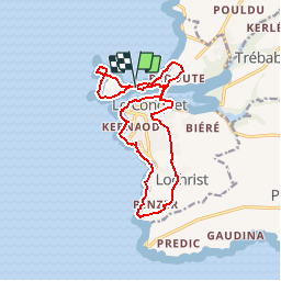

Length
15 km

Max alt
47 m

Uphill gradient
205 m
Km-Effort
17.7 km

Min alt
0 m

Downhill gradient
203 m
Boucle
Yes
Creation date :
2016-12-13 00:00:00.0
Updated on :
2016-12-13 00:00:00.0
3h55
Difficulty : Medium

FREE GPS app for hiking
 SityTrail
IGN / Geographical institutes
SityTrail Plus
The world is yours!
About
Trail Walking of 15 km to be discovered at Brittany, Finistère, Le Conquet. This trail is proposed by daniel77.
Positioning
Country:
France
Region :
Brittany
Department/Province :
Finistère
Municipality :
Le Conquet
Location:
Unknown
Start:(Dec)
Start:(UTM)
368485 ; 5358284 (30U) N.
Comments