


Le piton de la Fournaise

christian19
User
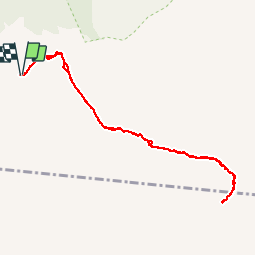

Length
13.8 km

Max alt
2490 m

Uphill gradient
529 m
Km-Effort
21 km

Min alt
2213 m

Downhill gradient
528 m
Boucle
Yes
Creation date :
2016-12-15 00:00:00.0
Updated on :
2016-12-15 00:00:00.0
5h40
Difficulty : Medium

FREE GPS app for hiking
 SityTrail
IGN / Geographical institutes
SityTrail Plus
The world is yours!
About
Trail Walking of 13.8 km to be discovered at Réunion, Unknown, Sainte-Rose. This trail is proposed by christian19.
Description
La Reunion
Positioning
Country:
France
Region :
Réunion
Department/Province :
Unknown
Municipality :
Sainte-Rose
Location:
Unknown
Start:(Dec)
Start:(UTM)
363516 ; 7652366 (40K) S.
Comments