


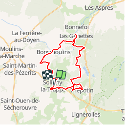
Soligny la Trappe 26

togolo28
User

Length
26 km

Max alt
304 m

Uphill gradient
386 m
Km-Effort
31 km

Min alt
225 m

Downhill gradient
386 m
Boucle
Yes
Creation date :
2017-09-11 00:00:00.0
Updated on :
2017-09-11 00:00:00.0
6h36
Difficulty : Medium

FREE GPS app for hiking
 SityTrail
IGN / Geographical institutes
SityTrail Plus
The world is yours!
About
Trail Walking of 26 km to be discovered at Normandy, Orne, Soligny-la-Trappe. This trail is proposed by togolo28.
Positioning
Country:
France
Region :
Normandy
Department/Province :
Orne
Municipality :
Soligny-la-Trappe
Location:
Unknown
Start:(Dec)
Start:(UTM)
318545 ; 5387855 (31U) N.
Comments