


67 LUTZELBOURG

LUTZMarc
User
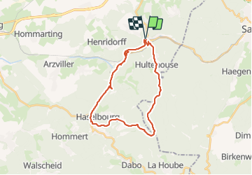

Length
25 km

Max alt
517 m

Uphill gradient
630 m
Km-Effort
33 km

Min alt
210 m

Downhill gradient
631 m
Boucle
Yes
Creation date :
2017-06-29 00:00:00.0
Updated on :
2017-06-29 00:00:00.0
5h28
Difficulty : Medium

FREE GPS app for hiking
 SityTrail
IGN / Geographical institutes
SityTrail Plus
The world is yours!
About
Trail Walking of 25 km to be discovered at Grand Est, Moselle, Lutzelbourg. This trail is proposed by LUTZMarc.
Description
Belle balade ,passage incontournable le resto à HELLERT
Positioning
Country:
France
Region :
Grand Est
Department/Province :
Moselle
Municipality :
Lutzelbourg
Location:
Unknown
Start:(Dec)
Start:(UTM)
371371 ; 5399479 (32U) N.
Comments