


Mauressac Lagrace Dieu

pidjam
User
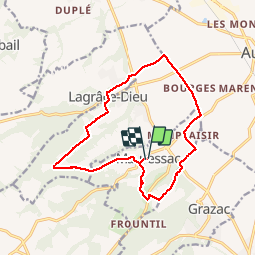

Length
15.4 km

Max alt
322 m

Uphill gradient
238 m
Km-Effort
18.6 km

Min alt
186 m

Downhill gradient
236 m
Boucle
Yes
Creation date :
2016-12-19 00:00:00.0
Updated on :
2016-12-19 00:00:00.0
4h02
Difficulty : Easy

FREE GPS app for hiking
 SityTrail
IGN / Geographical institutes
SityTrail Plus
The world is yours!
About
Trail Walking of 15.4 km to be discovered at Occitania, Haute-Garonne, Mauressac. This trail is proposed by pidjam.
Description
Une balade assez bien balisée dans la campagne autour du clocher de Puydaniel. De la forêt, du coteau, un passage en plaine puis de nouveau des coteaux.
Photos


Positioning
Country:
France
Region :
Occitania
Department/Province :
Haute-Garonne
Municipality :
Mauressac
Location:
Unknown
Start:(Dec)
Start:(UTM)
373108 ; 4798014 (31T) N.
Comments