


2016-12-20 Running Session

holtzv
User GUIDE
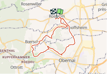

Length
16.1 km

Max alt
309 m

Uphill gradient
303 m
Km-Effort
20 km

Min alt
182 m

Downhill gradient
298 m
Boucle
Yes
Creation date :
2016-12-21 00:00:00.0
Updated on :
2016-12-21 00:00:00.0
1h28
Difficulty : Medium

FREE GPS app for hiking
 SityTrail
IGN / Geographical institutes
SityTrail Plus
The world is yours!
About
Trail Running of 16.1 km to be discovered at Grand Est, Bas-Rhin, Rosheim. This trail is proposed by holtzv.
Positioning
Country:
France
Region :
Grand Est
Department/Province :
Bas-Rhin
Municipality :
Rosheim
Location:
Unknown
Start:(Dec)
Start:(UTM)
386898 ; 5372414 (32U) N.
Comments