ver sur launette MN 12.1 km

dartoisclaude
User
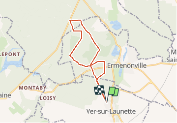

Length
12.1 km

Max alt
129 m

Uphill gradient
129 m
Km-Effort
13.8 km

Min alt
91 m

Downhill gradient
130 m
Boucle
Yes
Creation date :
2016-12-23 00:00:00.0
Updated on :
2016-12-23 00:00:00.0
1h30
Difficulty : Difficult

FREE GPS app for hiking
 SityTrail
IGN / Geographical institutes
SityTrail Plus
The world is yours!
About
Trail Nordic walking of 12.1 km to be discovered at Hauts-de-France, Oise, Ver-sur-Launette. This trail is proposed by dartoisclaude.
Description
Marcheur nordique rapide
Parking rue de la foret VER SUR LAUNETTE
Positioning
Country:
France
Region :
Hauts-de-France
Department/Province :
Oise
Municipality :
Ver-sur-Launette
Location:
Unknown
Start:(Dec)
Start:(UTM)
476753 ; 5439627 (31U) N.
Comments