


Etang du Corra 02

dufland
User
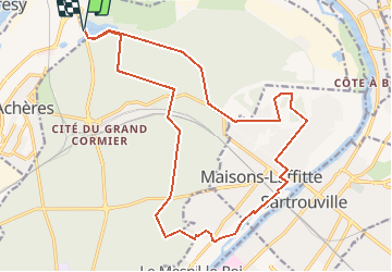

Length
20 km

Max alt
78 m

Uphill gradient
173 m
Km-Effort
23 km

Min alt
21 m

Downhill gradient
172 m
Boucle
Yes
Creation date :
2019-04-16 12:59:21.492
Updated on :
2019-04-16 12:59:21.521
4h55
Difficulty : Easy

FREE GPS app for hiking
 SityTrail
IGN / Geographical institutes
SityTrail Plus
The world is yours!
About
Trail Walking of 20 km to be discovered at Ile-de-France, Yvelines, Saint-Germain-en-Laye. This trail is proposed by dufland.
Positioning
Country:
France
Region :
Ile-de-France
Department/Province :
Yvelines
Municipality :
Saint-Germain-en-Laye
Location:
Saint-Germain-en-Laye
Start:(Dec)
Start:(UTM)
433331 ; 5425264 (31U) N.
Comments