


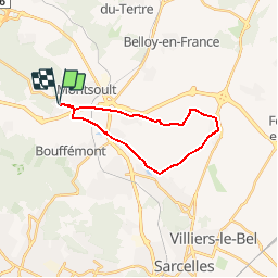
Baillet 07/Mesnil Aubry

dufland
User

Length
18.4 km

Max alt
122 m

Uphill gradient
141 m
Km-Effort
20 km

Min alt
79 m

Downhill gradient
140 m
Boucle
Yes
Creation date :
2019-04-16 12:59:21.196
Updated on :
2019-04-16 12:59:21.225
4h28
Difficulty : Easy

FREE GPS app for hiking
 SityTrail
IGN / Geographical institutes
SityTrail Plus
The world is yours!
About
Trail Walking of 18.4 km to be discovered at Ile-de-France, Val-d'Oise, Baillet-en-France. This trail is proposed by dufland.
Positioning
Country:
France
Region :
Ile-de-France
Department/Province :
Val-d'Oise
Municipality :
Baillet-en-France
Location:
Unknown
Start:(Dec)
Start:(UTM)
448902 ; 5434678 (31U) N.
Comments