


givry-mellecey

XavierFaidix
User
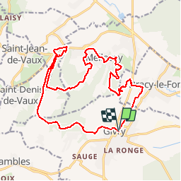

Length
21 km

Max alt
437 m

Uphill gradient
543 m
Km-Effort
28 km

Min alt
211 m

Downhill gradient
541 m
Boucle
Yes
Creation date :
2019-04-01 20:34:34.417
Updated on :
2019-04-01 20:34:34.478
2h43
Difficulty : Difficult

FREE GPS app for hiking
 SityTrail
IGN / Geographical institutes
SityTrail Plus
The world is yours!
About
Trail Mountain bike of 21 km to be discovered at Bourgogne-Franche-Comté, Saône-et-Loire, Givry. This trail is proposed by XavierFaidix.
Description
très beau parcours autour de Givry, très technique
Positioning
Country:
France
Region :
Bourgogne-Franche-Comté
Department/Province :
Saône-et-Loire
Municipality :
Givry
Location:
Unknown
Start:(Dec)
Start:(UTM)
633248 ; 5182578 (31T) N.
Comments