


Stambach-Romanswiller 06-2011

baggera
User
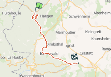

Length
18 km

Max alt
409 m

Uphill gradient
387 m
Km-Effort
23 km

Min alt
212 m

Downhill gradient
384 m
Boucle
No
Creation date :
2014-12-10 00:00:00.0
Updated on :
2014-12-10 00:00:00.0
--
Difficulty : Medium

FREE GPS app for hiking
 SityTrail
IGN / Geographical institutes
SityTrail Plus
The world is yours!
About
Trail Equestrian of 18 km to be discovered at Grand Est, Bas-Rhin, Haegen. This trail is proposed by baggera.
Description
Balade à cheval, départ Stambach - arrivée Romanswiller
Positioning
Country:
France
Region :
Grand Est
Department/Province :
Bas-Rhin
Municipality :
Haegen
Location:
Unknown
Start:(Dec)
Start:(UTM)
376004 ; 5397683 (32U) N.
Comments