


le sentier de la gravette

xav34830
User
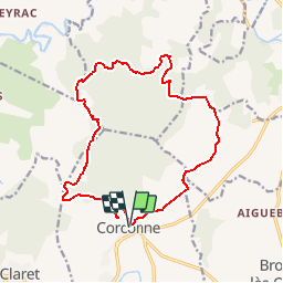

Length
17.6 km

Max alt
437 m

Uphill gradient
490 m
Km-Effort
24 km

Min alt
143 m

Downhill gradient
493 m
Boucle
Yes
Creation date :
2017-01-01 00:00:00.0
Updated on :
2017-01-01 00:00:00.0
--
Difficulty : Medium

FREE GPS app for hiking
 SityTrail
IGN / Geographical institutes
SityTrail Plus
The world is yours!
About
Trail Walking of 17.6 km to be discovered at Occitania, Gard, Corconne. This trail is proposed by xav34830.
Positioning
Country:
France
Region :
Occitania
Department/Province :
Gard
Municipality :
Corconne
Location:
Unknown
Start:(Dec)
Start:(UTM)
575529 ; 4858159 (31T) N.
Comments