


03.01.2017 - ALZHEIMER ERIC

babeth35
User
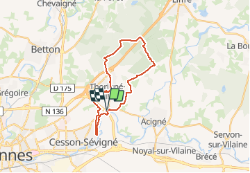

Length
24 km

Max alt
121 m

Uphill gradient
244 m
Km-Effort
27 km

Min alt
28 m

Downhill gradient
244 m
Boucle
Yes
Creation date :
2017-01-03 00:00:00.0
Updated on :
2020-07-20 15:25:28.217
5h18
Difficulty : Easy

FREE GPS app for hiking
 SityTrail
IGN / Geographical institutes
SityTrail Plus
The world is yours!
About
Trail Walking of 24 km to be discovered at Brittany, Ille-et-Vilaine, Thorigné-Fouillard. This trail is proposed by babeth35.
Positioning
Country:
France
Region :
Brittany
Department/Province :
Ille-et-Vilaine
Municipality :
Thorigné-Fouillard
Location:
Unknown
Start:(Dec)
Start:(UTM)
605639 ; 5332928 (30U) N.
Comments