


Herault - Le Mont St-Baudille 11km 452m

RandoVal
User
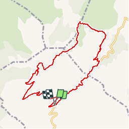

Length
10.4 km

Max alt
840 m

Uphill gradient
450 m
Km-Effort
16.4 km

Min alt
400 m

Downhill gradient
453 m
Boucle
Yes
Creation date :
2018-09-12 19:08:55.438
Updated on :
2018-09-12 19:08:55.446
3h27
Difficulty : Difficult

FREE GPS app for hiking
 SityTrail
IGN / Geographical institutes
SityTrail Plus
The world is yours!
About
Trail Walking of 10.4 km to be discovered at Occitania, Hérault, Montpeyroux. This trail is proposed by RandoVal.
Description
Boucle dans le massif de la Serrane, départ devant le gite La Font de Griffe sens horaire, beau point de vue au sommet.
Positioning
Country:
France
Region :
Occitania
Department/Province :
Hérault
Municipality :
Montpeyroux
Location:
Unknown
Start:(Dec)
Start:(UTM)
539628 ; 4842527 (31T) N.
Comments