


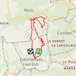
Hérault - Colombière-sur-l Orb Madale 19km 969m

RandoVal
User


5h23
Difficulty : Difficult

FREE GPS app for hiking
 SityTrail
IGN / Geographical institutes
SityTrail Plus
The world is yours!
About
Trail Walking of 15.3 km to be discovered at Occitania, Hérault, Colombières-sur-Orb. This trail is proposed by RandoVal.
Description
Boucle à l'ouest du massif du Caroux. Parking randonneurs derrière la mairie de Colombière-sur-l'Orb, sens horaire. On suit le PR 22 plus une boucle sur les crêtes vers Madale. Un peu de hors piste après Madale
Positioning
Comments