


Saverdun-le château

pidjam
User
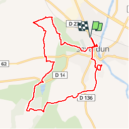

Length
10.8 km

Max alt
312 m

Uphill gradient
190 m
Km-Effort
13.4 km

Min alt
227 m

Downhill gradient
190 m
Boucle
Yes
Creation date :
2017-01-12 00:00:00.0
Updated on :
2017-01-12 00:00:00.0
2h52
Difficulty : Easy

FREE GPS app for hiking
 SityTrail
IGN / Geographical institutes
SityTrail Plus
The world is yours!
About
Trail Walking of 10.8 km to be discovered at Occitania, Ariège, Saverdun. This trail is proposed by pidjam.
Description
Belle boucle autour de Saverdun (pas de château à voir -c'est juste un quartier). Attention aux périodes humides sur la fin (risque de chutes près du cours d'eau -Lansonne- vers la fin)
Positioning
Country:
France
Region :
Occitania
Department/Province :
Ariège
Municipality :
Saverdun
Location:
Unknown
Start:(Dec)
Start:(UTM)
384196 ; 4788173 (31T) N.
Comments