Trail Walking Saint-Maurice-sur-Aveyron - Pr de Bellefontaine - Photo
© OpenStreetMap contributors
Length
Length
9.9 km
Max alt
Max alt
179 m
Uphill gradient
Uphill gradient
91 m
Km-Effort
Km-Effort  
11.2 km
Min alt
Min alt
142 m
Downhill gradient
Downhill gradient
90 m
Boucle
Boucle
Yes
Creation date :
2019-05-03 09:15:00.637
Updated on :
2019-05-03 09:15:00.708

(0 Reviews)

Walking
Walking
2h28
Difficulty : Easy

Scan this QR Code to open this trail in the SityTrail application

FREE GPS app for hiking

Logo SityTrail SityTrail

IGN / Geographical institutes

Download SityTrail from the App Store Download SityTrail from Google Play

Logo SityTrail SityTrail World

The world is yours!

Download SityTrail from the App Store Download SityTrail from Google Play Download SityTrail on Huawei AppGallery

About

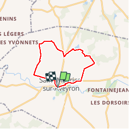
Trail Walking of 9.9 km to be discovered at Centre-Loire Valley, Loiret, Saint-Maurice-sur-Aveyron. This trail is proposed by Ordijamo45.

Description

Départ du parking de l'église de
St-Maurice-sur-Aveyron (45)
Rando facile à faire

Elevation profile

Photos

Positioning

Country:
France
Region :
Centre-Loire Valley
Department/Province :
Loiret
Municipality :
Saint-Maurice-sur-Aveyron
Location:
Unknown
Start:(UTM)
494466 ; 5299530 (31T) N.

Trails nearby

Trail Walking Saint-Maurice-sur-Aveyron - Saint Maurice sur Aveyron - Photo
Walking
PatRando

Walking

Medium
Saint-Maurice-sur-Aveyron, Centre-Loire Valley, Loiret, France
12.7 km | 14.8 km-effort
3h 16min
Yes
Trail On foot La Chapelle-sur-Aveyron - SityTrail - 2745022 - 2021x04x12_19h06m18_gpxxtrace - Photo
On foot
Ordijamo45

On foot

Very easy
La Chapelle-sur-Aveyron, Centre-Loire Valley, Loiret, France
9.9 km | 11.2 km-effort
Unknown
Yes
Trail Walking Saint-Maurice-sur-Aveyron - Fontaine jean 45  9km - Photo
Walking
picouleau220345

Walking

Easy
Saint-Maurice-sur-Aveyron, Centre-Loire Valley, Loiret, France
9 km | 10.3 km-effort
2h 17min
Yes
Trail Walking La Chapelle-sur-Aveyron - Pr des hauts de la Chapelle - Photo
Walking
Ordijamo45

Walking

Easy
La Chapelle-sur-Aveyron, Centre-Loire Valley, Loiret, France
14.7 km | 16.7 km-effort
3h 40min
Yes
Trail Walking Châtillon-Coligny - Chatillon Coligny - Photo
Walking
Ordijamo45

Walking

Easy
Châtillon-Coligny, Centre-Loire Valley, Loiret, France
12.2 km | 13.7 km-effort
3h 2min
Yes
Trail Walking Saint-Maurice-sur-Aveyron - saint maurice - Photo
Walking
picouleau220345

Walking

Very easy
Saint-Maurice-sur-Aveyron, Centre-Loire Valley, Loiret, France
13.1 km | 15 km-effort
2h 26min
Yes
Trail Walking La Chapelle-sur-Aveyron - la chapelle sur Aveyron 45 - Photo
Walking
picouleau220345

Walking

Medium
(1)
La Chapelle-sur-Aveyron, Centre-Loire Valley, Loiret, France
12.7 km | 14.2 km-effort
3h 0min
No
Trail Walking Saint-Maurice-sur-Aveyron - Fontainejean 45 11km8 - Photo
Walking
picouleau220345

Walking

Medium
Saint-Maurice-sur-Aveyron, Centre-Loire Valley, Loiret, France
12 km | 13.8 km-effort
3h 11min
Yes
Trail Walking La Chapelle-sur-Aveyron - La Chapelle sur Aveyron 45 9Km4 rando de groupe - Photo
Walking
picouleau220345

Walking

Very easy
La Chapelle-sur-Aveyron, Centre-Loire Valley, Loiret, France
9.4 km | 10.6 km-effort
2h 20min
Yes


Close
My subscriptions