


ravin des boulettes

mic-13
User

Length
11 km

Max alt
452 m

Uphill gradient
223 m
Km-Effort
14 km

Min alt
243 m

Downhill gradient
222 m
Boucle
Yes
Creation date :
2017-01-18 00:00:00.0
Updated on :
2017-01-18 00:00:00.0
--
Difficulty : Easy

FREE GPS app for hiking
 SityTrail
IGN / Geographical institutes
SityTrail Plus
The world is yours!
About
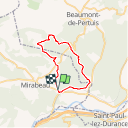
Trail Walking of 11 km to be discovered at Provence-Alpes-Côte d'Azur, Vaucluse, Mirabeau. This trail is proposed by mic-13.
Positioning
Country:
France
Region :
Provence-Alpes-Côte d'Azur
Department/Province :
Vaucluse
Municipality :
Mirabeau
Location:
Unknown
Start:(Dec)
Start:(UTM)
715327 ; 4842220 (31T) N.
Comments