


18.01.2017 - IFFS ET BECHEREL

babeth35
User
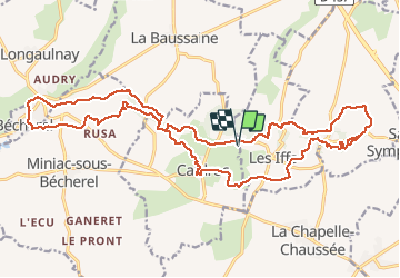

Length
26 km

Max alt
169 m

Uphill gradient
469 m
Km-Effort
32 km

Min alt
50 m

Downhill gradient
469 m
Boucle
Yes
Creation date :
2017-01-18 00:00:00.0
Updated on :
2020-07-20 15:25:06.107
6h26
Difficulty : Medium

FREE GPS app for hiking
 SityTrail
IGN / Geographical institutes
SityTrail Plus
The world is yours!
About
Trail Walking of 26 km to be discovered at Brittany, Ille-et-Vilaine, Cardroc. This trail is proposed by babeth35.
Positioning
Country:
France
Region :
Brittany
Department/Province :
Ille-et-Vilaine
Municipality :
Cardroc
Location:
Unknown
Start:(Dec)
Start:(UTM)
583253 ; 5349218 (30U) N.
Comments