


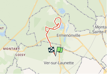
VER SUR LAUNETTE MN ETANG 2

dartoisclaude
User

Length
9.9 km

Max alt
117 m

Uphill gradient
123 m
Km-Effort
11.5 km

Min alt
83 m

Downhill gradient
124 m
Boucle
Yes
Creation date :
2017-01-20 00:00:00.0
Updated on :
2017-01-20 00:00:00.0
1h20
Difficulty : Difficult

FREE GPS app for hiking
 SityTrail
IGN / Geographical institutes
SityTrail Plus
The world is yours!
About
Trail Nordic walking of 9.9 km to be discovered at Hauts-de-France, Oise, Ver-sur-Launette. This trail is proposed by dartoisclaude.
Description
vue sur l'étang et cheminement autour et sur le plateau
Positioning
Country:
France
Region :
Hauts-de-France
Department/Province :
Oise
Municipality :
Ver-sur-Launette
Location:
Unknown
Start:(Dec)
Start:(UTM)
476713 ; 5439704 (31U) N.
Comments