


LarchantCRI160417SR161218 am

fmg
User
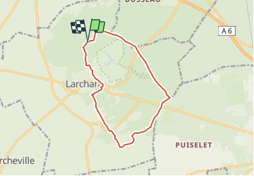

Length
12.3 km

Max alt
118 m

Uphill gradient
163 m
Km-Effort
14.5 km

Min alt
63 m

Downhill gradient
163 m
Boucle
Yes
Creation date :
2017-04-16 00:00:00.0
Updated on :
2018-09-05 09:00:40.964
12m
Difficulty : Unknown

FREE GPS app for hiking
 SityTrail
IGN / Geographical institutes
SityTrail Plus
The world is yours!
About
Trail Walking of 12.3 km to be discovered at Ile-de-France, Seine-et-Marne, Larchant. This trail is proposed by fmg.
Positioning
Country:
France
Region :
Ile-de-France
Department/Province :
Seine-et-Marne
Municipality :
Larchant
Location:
Unknown
Start:(Dec)
Start:(UTM)
470199 ; 5349487 (31U) N.
Comments