Trail Other activity Échauffour - Basse Normandie - Ligne 402 - Sainte-Gauburge - Mesnil-Mauger - Photo

Basse Normandie - Ligne 402 - Sainte-Gauburge - Mesnil-Mauger

 mich54
mich54

User

© OpenStreetMap contributors
Length
Length
61 km
Max alt
Max alt
317 m
Uphill gradient
Uphill gradient
347 m
Km-Effort
Km-Effort  
66 km
Min alt
Min alt
19 m
Downhill gradient
Downhill gradient
578 m
Boucle
Boucle
No
Creation date :
2017-01-22 00:00:00.0
Updated on :
2017-01-22 00:00:00.0

(0 Reviews)

Other activity
Other activity
5m
Difficulty : Unknown

Scan this QR Code to open this trail in the SityTrail application

FREE GPS app for hiking

Logo SityTrail SityTrail

IGN / Geographical institutes

Download SityTrail from the App Store Download SityTrail from Google Play

Logo SityTrail SityTrail World

The world is yours!

Download SityTrail from the App Store Download SityTrail from Google Play Download SityTrail on Huawei AppGallery

About

Trail Other activity of 61 km to be discovered at Normandy, Orne, Échauffour. This trail is proposed by mich54.

Description

La ligne de Sainte-Gauburge au Mesnil-Mauger est une ancienne ligne de chemin de fer française reliant Sainte-Gauburge-Sainte-Colombe, dans le département de l'Orne, au Mesnil-Mauger, dans le Calvados, en région Basse-Normandie.
Aujourd'hui, la ligne est maintenant transformée en voie verte, appelée la Coulée verte, de Vimoutiers au Mesnil-Mauger. S'y déroule annuellement la course pédestre des foulées du Terroir entre Livarot et Vimoutiers.(Source Wikipédia)

Elevation profile

Positioning

Country:
France
Region :
Normandy
Department/Province :
Orne
Municipality :
Échauffour
Location:
Unknown
Start:(UTM)
309374 ; 5399106 (31U) N.

Trails nearby

Trail Car La Genevraie - 2023-03-01 maheru Vdu P - Photo
Car
patrick2m

Car

La Genevraie, Normandy, Orne, France
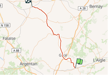
43 km | 49 km-effort
2h 30min
No
Trail Other activity Échauffour - Haute Normandie - Ligne 400 - Echauffour - Bernay (Section de Echauffour à la limite Eure/Orne) 1 - Photo
Other activity
mich54

Other activity

Very easy
Échauffour, Normandy, Orne, France
18.7 km | 21 km-effort
5min
No
Trail Cycle Échauffour - EchauSolignyEvroult - Photo
Cycle
sylvain75

Cycle

Easy
Échauffour, Normandy, Orne, France
73 km | 85 km-effort
3h 0min
Yes
Trail Cycle Échauffour - Autour de Gacé - Photo
Cycle
sylvain75

Cycle

Medium
Échauffour, Normandy, Orne, France
69 km | 80 km-effort
4h 38min
Yes
Trail Cycle Échauffour - echauf_char_touq_har - Photo
Cycle
sylvain75

Cycle

Medium
Échauffour, Normandy, Orne, France
108 km | 125 km-effort
Unknown
Yes
Trail Cycle Échauffour - champs haut gacé - Photo
Cycle
sylvain75

Cycle

Easy
Échauffour, Normandy, Orne, France
32 km | 38 km-effort
1h 19min
Yes
Trail Cycle Échauffour - Vélo - Photo
Cycle
sylvain75

Cycle

Very easy
Échauffour, Normandy, Orne, France
68 km | 79 km-effort
Unknown
Yes


Close
My subscriptions