


Entre Sillans et Izeaux

dan48
User
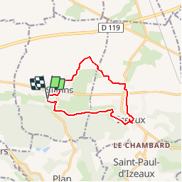

Length
10.7 km

Max alt
468 m

Uphill gradient
143 m
Km-Effort
12.6 km

Min alt
400 m

Downhill gradient
144 m
Boucle
Yes
Creation date :
2017-01-27 00:00:00.0
Updated on :
2017-01-27 00:00:00.0
3h00
Difficulty : Easy

FREE GPS app for hiking
 SityTrail
IGN / Geographical institutes
SityTrail Plus
The world is yours!
About
Trail Walking of 10.7 km to be discovered at Auvergne-Rhône-Alpes, Isère, Sillans. This trail is proposed by dan48.
Positioning
Country:
France
Region :
Auvergne-Rhône-Alpes
Department/Province :
Isère
Municipality :
Sillans
Location:
Unknown
Start:(Dec)
Start:(UTM)
686946 ; 5023462 (31T) N.
Comments