


GTJ - 3

cron
User
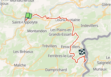

Length
28 km

Max alt
983 m

Uphill gradient
1039 m
Km-Effort
41 km

Min alt
372 m

Downhill gradient
915 m
Boucle
No
Creation date :
2017-03-05 00:00:00.0
Updated on :
2017-03-05 00:00:00.0
8h43
Difficulty : Very difficult

FREE GPS app for hiking
 SityTrail
IGN / Geographical institutes
SityTrail Plus
The world is yours!
About
Trail Walking of 28 km to be discovered at Bourgogne-Franche-Comté, Doubs, Saint-Hippolyte. This trail is proposed by cron.
Positioning
Country:
France
Region :
Bourgogne-Franche-Comté
Department/Province :
Doubs
Municipality :
Saint-Hippolyte
Location:
Unknown
Start:(Dec)
Start:(UTM)
334604 ; 5242639 (32T) N.
Comments