


GTJ 17

cron
User
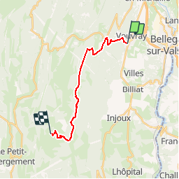

Length
15.8 km

Max alt
1351 m

Uphill gradient
810 m
Km-Effort
25 km

Min alt
600 m

Downhill gradient
318 m
Boucle
No
Creation date :
2017-03-05 00:00:00.0
Updated on :
2017-03-05 00:00:00.0
5h28
Difficulty : Medium

FREE GPS app for hiking
 SityTrail
IGN / Geographical institutes
SityTrail Plus
The world is yours!
About
Trail Walking of 15.8 km to be discovered at Auvergne-Rhône-Alpes, Ain, Valserhône. This trail is proposed by cron.
Positioning
Country:
France
Region :
Auvergne-Rhône-Alpes
Department/Province :
Ain
Municipality :
Valserhône
Location:
Châtillon-en-Michaille
Start:(Dec)
Start:(UTM)
714717 ; 5109914 (31T) N.
Comments