


GTJ 19

cron
User
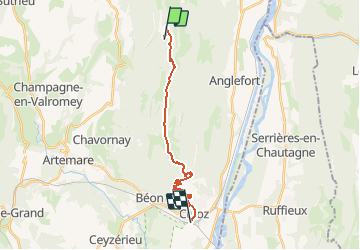

Length
18 km

Max alt
1523 m

Uphill gradient
428 m
Km-Effort
27 km

Min alt
236 m

Downhill gradient
1363 m
Boucle
No
Creation date :
2017-03-05 00:00:00.0
Updated on :
2017-03-05 00:00:00.0
5h13
Difficulty : Difficult

FREE GPS app for hiking
 SityTrail
IGN / Geographical institutes
SityTrail Plus
The world is yours!
About
Trail Walking of 18 km to be discovered at Auvergne-Rhône-Alpes, Ain, Arvière-en-Valromey. This trail is proposed by cron.
Positioning
Country:
France
Region :
Auvergne-Rhône-Alpes
Department/Province :
Ain
Municipality :
Arvière-en-Valromey
Location:
Lochieu
Start:(Dec)
Start:(UTM)
713955 ; 5090152 (31T) N.
Comments