


Estenc Haut Var J1

GrouGary
User
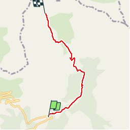

Length
4.6 km

Max alt
2451 m

Uphill gradient
450 m
Km-Effort
9.1 km

Min alt
1996 m

Downhill gradient
4 m
Boucle
No
Creation date :
2017-01-30 00:00:00.0
Updated on :
2017-01-30 00:00:00.0
5h00
Difficulty : Easy

FREE GPS app for hiking
 SityTrail
IGN / Geographical institutes
SityTrail Plus
The world is yours!
About
Trail Snowshoes of 4.6 km to be discovered at Provence-Alpes-Côte d'Azur, Maritime Alps, Entraunes. This trail is proposed by GrouGary.
Description
Montée A/R en raquettes le long du ravin de la Sanguinière, cabanes de la Sanguinière, vallon de la Boucharde, cabane pastorale, Col enneigé, plaques...
Positioning
Country:
France
Region :
Provence-Alpes-Côte d'Azur
Department/Province :
Maritime Alps
Municipality :
Entraunes
Location:
Unknown
Start:(Dec)
Start:(UTM)
321533 ; 4902057 (32T) N.
Comments