porte du Rouet

aljac
User
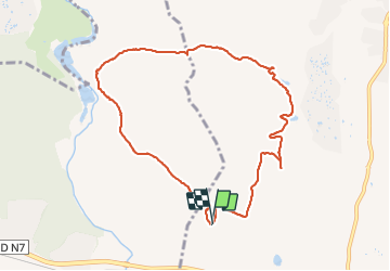

Length
9.6 km

Max alt
84 m

Uphill gradient
145 m
Km-Effort
11.6 km

Min alt
25 m

Downhill gradient
145 m
Boucle
Yes
Creation date :
2017-02-01 00:00:00.0
Updated on :
2017-02-01 00:00:00.0
2h29
Difficulty : Unknown

FREE GPS app for hiking
 SityTrail
IGN / Geographical institutes
SityTrail Plus
The world is yours!
About
Trail Other activity of 9.6 km to be discovered at Provence-Alpes-Côte d'Azur, Var, Roquebrune-sur-Argens. This trail is proposed by aljac.
Positioning
Country:
France
Region :
Provence-Alpes-Côte d'Azur
Department/Province :
Var
Municipality :
Roquebrune-sur-Argens
Location:
Unknown
Start:(Dec)
Start:(UTM)
306945 ; 4816043 (32T) N.
Comments