Trail Walking Burgos - Mon Compostelle  vingt deuxième étape - Photo

Mon Compostelle vingt deuxième étape

© OpenStreetMap contributors
Length
Length
41 km
Max alt
Max alt
939 m
Uphill gradient
Uphill gradient
451 m
Km-Effort
Km-Effort  
47 km
Min alt
Min alt
783 m
Downhill gradient
Downhill gradient
509 m
Boucle
Boucle
No
Creation date :
2017-02-04 00:00:00.0
Updated on :
2017-02-04 00:00:00.0

(0 Reviews)

Walking
Walking
8h15
Difficulty : Medium

Scan this QR Code to open this trail in the SityTrail application

FREE GPS app for hiking

Logo SityTrail SityTrail

IGN / Geographical institutes

Download SityTrail from the App Store Download SityTrail from Google Play

Logo SityTrail SityTrail World

The world is yours!

Download SityTrail from the App Store Download SityTrail from Google Play Download SityTrail on Huawei AppGallery

About

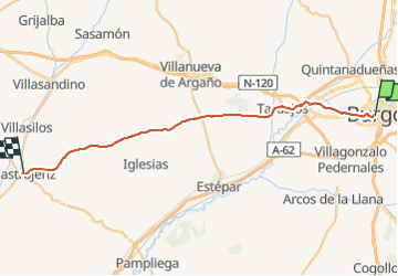
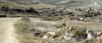
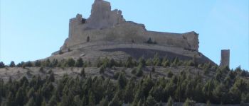
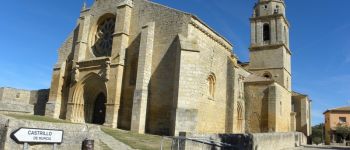
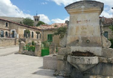
Trail Walking of 41 km to be discovered at Castile and León, Burgos, Burgos. This trail is proposed by Ardeiserois.

Description

Vingt deuxième étape, mercredi 14 octobre 2009, Burgos / Castrojeriz
Départ: 8h00
Arrivée : 16h15

Elevation profile

Photos

Points of interest

Point of interest Burgos - Burgos - Photo
Ardeiserois
BURGOS 
Point of interest Burgos - Burgos - Photo
Ardeiserois
BURGOS 
Point of interest Rabé de las Calzadas - Rabe de la Calzadas - Photo
Ardeiserois
RABÉ DE LAS CALZADAS 
Point of interest Castrojeriz - Monasterio de San Anton - Photo
Ardeiserois
Point of interest Hontanas - Hontana - Photo
Ardeiserois
HONTANAS 
Point of interest Castrojeriz - Castrojeriz - Photo
Ardeiserois
CASTROJERIZ 
Point of interest Castrojeriz - Castojeriz - Photo
Ardeiserois
CASTROJERIZ 
Point of interest Burgos - Burgos - Photo
Ardeiserois
BURGOS 
Point of interest Castrojeriz - Castrojeriz - Photo
Ardeiserois
CASTROJERIZ 

Positioning

Country:
Spain
Region :
Castile and León
Department/Province :
Burgos
Municipality :
Burgos
Location:
Unknown
Start:(UTM)
442019 ; 4688021 (30T) N.

Trails nearby

Trail On foot Burgos - Paseos por el Cinturón Verde: La Lora - Cerro de la Galga - Photo
On foot
PRO

On foot

Easy
Burgos, Castile and León, Burgos, Spain
4.9 km | 6.3 km-effort
1h 25min
No
Trail On foot Burgos - Paseos por el Cinturón Verde: Barrio de Villatoro - Monasterio de Fredesval - Photo
On foot
PRO

On foot

Easy
Burgos, Castile and León, Burgos, Spain
11.8 km | 15.2 km-effort
3h 27min
No
Trail On foot Burgos - Paseos por el Cinturón Verde: Cartuja de Miraflores - Photo
On foot
PRO

On foot

Easy
Burgos, Castile and León, Burgos, Spain
10.1 km | 12.3 km-effort
2h 48min
No
Trail On foot Burgos - Paseos por el Cinturón Verde: Fábrica de la Moneda y Timbre - Barrio de Villalonquéjar - Photo
On foot
PRO

On foot

Easy
Burgos, Castile and León, Burgos, Spain
9.2 km | 10 km-effort
2h 15min
Yes
Trail On foot Burgos - Los caminos del agua siguiendo el Arlanzón - Photo
On foot
PRO

On foot

Easy
Burgos, Castile and León, Burgos, Spain
5.6 km | 6.5 km-effort
1h 28min
No
Trail Walking Burgos - 2023 10 24 CAMINO FRANCES - 32ème étape : Burgos - Tardajos - Rabelais de l’as Calzadas - Hornillos Del Camino - Hontanas  - Photo
Walking
LEGUE

Walking

Medium
Burgos, Castile and León, Burgos, Spain
32 km | 37 km-effort
6h 30min
No
Trail On foot Burgos - Paseos por el Cinturón Verde: Santimia - Photo
On foot
PRO

On foot

Easy
Burgos, Castile and León, Burgos, Spain
3.5 km | 4.6 km-effort
1h 2min
No
Trail Walking Burgos - CC_Frances_CA_13_Burgos_Hontanas_20110704 - Photo
Walking
patrickdanilo

Walking

Easy
Burgos, Castile and León, Burgos, Spain
31 km | 36 km-effort
7h 0min
No
Trail Walking Burgos - Compostelle 46 - Burgos -> Hornillo/Isar - Photo
Walking
uru2010

Walking

Easy
Burgos, Castile and León, Burgos, Spain
25 km | 29 km-effort
5h 30min
No


Close
My subscriptions