


Cogny (69)

Thomasdanielle
User
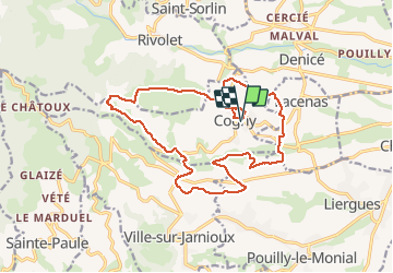

Length
18.6 km

Max alt
537 m

Uphill gradient
549 m
Km-Effort
26 km

Min alt
259 m

Downhill gradient
550 m
Boucle
Yes
Creation date :
2017-03-18 00:00:00.0
Updated on :
2017-03-18 00:00:00.0
5h28
Difficulty : Medium

FREE GPS app for hiking
 SityTrail
IGN / Geographical institutes
SityTrail Plus
The world is yours!
About
Trail Walking of 18.6 km to be discovered at Auvergne-Rhône-Alpes, Rhône, Cogny. This trail is proposed by Thomasdanielle.
Description
Départ salle des fêtes (06/02/2017)
18,6 km - D. 552 m
Positioning
Country:
France
Region :
Auvergne-Rhône-Alpes
Department/Province :
Rhône
Municipality :
Cogny
Location:
Unknown
Start:(Dec)
Start:(UTM)
626004 ; 5093955 (31T) N.
Comments