


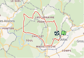
Chandolas Les capitelles

coureursdecretes
User

Length
16.8 km

Max alt
246 m

Uphill gradient
314 m
Km-Effort
21 km

Min alt
113 m

Downhill gradient
315 m
Boucle
Yes
Creation date :
2017-02-07 00:00:00.0
Updated on :
2021-12-20 19:55:49.798
4h36
Difficulty : Easy

FREE GPS app for hiking
 SityTrail
IGN / Geographical institutes
SityTrail Plus
The world is yours!
About
Trail Walking of 16.8 km to be discovered at Auvergne-Rhône-Alpes, Ardèche, Chandolas. This trail is proposed by coureursdecretes.
Description
Rando du 6-2-2017
Positioning
Country:
France
Region :
Auvergne-Rhône-Alpes
Department/Province :
Ardèche
Municipality :
Chandolas
Location:
Unknown
Start:(Dec)
Start:(UTM)
599808 ; 4917432 (31T) N.
Comments