


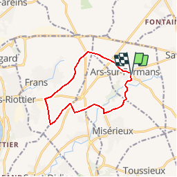
ARS SUR FORMANS

Thomasdanielle
User

Length
10.8 km

Max alt
263 m

Uphill gradient
102 m
Km-Effort
12.1 km

Min alt
221 m

Downhill gradient
99 m
Boucle
Yes
Creation date :
2017-02-09 00:00:00.0
Updated on :
2017-02-09 00:00:00.0
2h41
Difficulty : Very easy

FREE GPS app for hiking
 SityTrail
IGN / Geographical institutes
SityTrail Plus
The world is yours!
About
Trail Walking of 10.8 km to be discovered at Auvergne-Rhône-Alpes, Ain, Ars-sur-Formans. This trail is proposed by Thomasdanielle.
Description
Départ parking Place Freiralden
10,8 km - D. 96 m
Positioning
Country:
France
Region :
Auvergne-Rhône-Alpes
Department/Province :
Ain
Municipality :
Ars-sur-Formans
Location:
Unknown
Start:(Dec)
Start:(UTM)
640999 ; 5094954 (31T) N.
Comments