


condorcet

Joel26400
User

Length
22 km

Max alt
863 m

Uphill gradient
775 m
Km-Effort
32 km

Min alt
340 m

Downhill gradient
776 m
Boucle
Yes
Creation date :
2017-02-09 00:00:00.0
Updated on :
2017-02-09 00:00:00.0
6h48
Difficulty : Unknown

FREE GPS app for hiking
 SityTrail
IGN / Geographical institutes
SityTrail Plus
The world is yours!
About
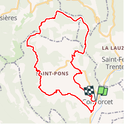
Trail Other activity of 22 km to be discovered at Auvergne-Rhône-Alpes, Drôme, Condorcet. This trail is proposed by Joel26400.
Positioning
Country:
France
Region :
Auvergne-Rhône-Alpes
Department/Province :
Drôme
Municipality :
Condorcet
Location:
Unknown
Start:(Dec)
Start:(UTM)
675097 ; 4919435 (31T) N.
Comments