


MAUVES

jphugon
User

Length
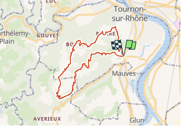
17.4 km

Max alt
513 m

Uphill gradient
605 m
Km-Effort
25 km

Min alt
124 m

Downhill gradient
603 m
Boucle
Yes
Creation date :
2017-02-09 00:00:00.0
Updated on :
2017-02-09 00:00:00.0
6h23
Difficulty : Medium

FREE GPS app for hiking
 SityTrail
IGN / Geographical institutes
SityTrail Plus
The world is yours!
About
Trail Walking of 17.4 km to be discovered at Auvergne-Rhône-Alpes, Ardèche, Tournon-sur-Rhône. This trail is proposed by jphugon.
Description
bcp de route gr dénivelé, 700 M, 17 km
Positioning
Country:
France
Region :
Auvergne-Rhône-Alpes
Department/Province :
Ardèche
Municipality :
Tournon-sur-Rhône
Location:
Unknown
Start:(Dec)
Start:(UTM)
644029 ; 4989764 (31T) N.
Comments