


rando 12 km Montsegur

Valery01
User
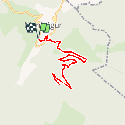

Length
11.8 km

Max alt
1396 m

Uphill gradient
608 m
Km-Effort
19.9 km

Min alt
864 m

Downhill gradient
607 m
Boucle
Yes
Creation date :
2014-12-10 00:00:00.0
Updated on :
2014-12-10 00:00:00.0
--
Difficulty : Difficult

FREE GPS app for hiking
 SityTrail
IGN / Geographical institutes
SityTrail Plus
The world is yours!
About
Trail Walking of 11.8 km to be discovered at Occitania, Ariège, Montségur. This trail is proposed by Valery01.
Positioning
Country:
France
Region :
Occitania
Department/Province :
Ariège
Municipality :
Montségur
Location:
Unknown
Start:(Dec)
Start:(UTM)
404602 ; 4746729 (31T) N.
Comments