


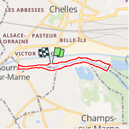
Boucle Réserve naturelle de Vaires

katiab
User

Length
5.1 km

Max alt
43 m

Uphill gradient
21 m
Km-Effort
5.4 km

Min alt
34 m

Downhill gradient
20 m
Boucle
Yes
Creation date :
2018-04-16 08:46:40.146
Updated on :
2019-06-12 10:32:16.421
1h08
Difficulty : Very easy

FREE GPS app for hiking
 SityTrail
IGN / Geographical institutes
SityTrail Plus
The world is yours!
About
Trail Walking of 5.1 km to be discovered at Ile-de-France, Seine-et-Marne, Chelles. This trail is proposed by katiab.
Photos


Positioning
Country:
France
Region :
Ile-de-France
Department/Province :
Seine-et-Marne
Municipality :
Chelles
Location:
Unknown
Start:(Dec)
Start:(UTM)
469701 ; 5412651 (31U) N.
Comments