


2017-02-17.gpx

georgein
User
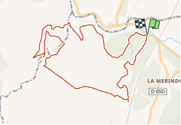

Length
14 km

Max alt
253 m

Uphill gradient
323 m
Km-Effort
18.3 km

Min alt
96 m

Downhill gradient
324 m
Boucle
Yes
Creation date :
2019-08-04 09:23:27.446
Updated on :
2020-01-31 20:34:40.093
--
Difficulty : Unknown

FREE GPS app for hiking
 SityTrail
IGN / Geographical institutes
SityTrail Plus
The world is yours!
About
Trail Walking of 14 km to be discovered at Provence-Alpes-Côte d'Azur, Bouches-du-Rhône, Aix-en-Provence. This trail is proposed by georgein.
Positioning
Country:
France
Region :
Provence-Alpes-Côte d'Azur
Department/Province :
Bouches-du-Rhône
Municipality :
Aix-en-Provence
Location:
Unknown
Start:(Dec)
Start:(UTM)
687518 ; 4820467 (31T) N.
Comments