


Tanneron

aljac
User
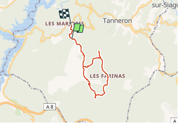

Length
13.5 km

Max alt
470 m

Uphill gradient
450 m
Km-Effort
19.5 km

Min alt
259 m

Downhill gradient
430 m
Boucle
No
Creation date :
2017-02-17 00:00:00.0
Updated on :
2017-02-17 00:00:00.0
4h41
Difficulty : Unknown

FREE GPS app for hiking
 SityTrail
IGN / Geographical institutes
SityTrail Plus
The world is yours!
About
Trail Other activity of 13.5 km to be discovered at Provence-Alpes-Côte d'Azur, Var, Tanneron. This trail is proposed by aljac.
Positioning
Country:
France
Region :
Provence-Alpes-Côte d'Azur
Department/Province :
Var
Municipality :
Tanneron
Location:
Unknown
Start:(Dec)
Start:(UTM)
325904 ; 4827569 (32T) N.
Comments