


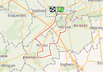
W2 Wizernes 12.4Km Dén 170m

alain62rando
User

Length
12.4 km

Max alt
119 m

Uphill gradient
168 m
Km-Effort
14.6 km

Min alt
23 m

Downhill gradient
167 m
Boucle
Yes
Creation date :
2017-12-24 00:00:00.0
Updated on :
2021-05-30 06:22:53.12
3h11
Difficulty : Medium

FREE GPS app for hiking
 SityTrail
IGN / Geographical institutes
SityTrail Plus
The world is yours!
About
Trail Walking of 12.4 km to be discovered at Hauts-de-France, Pas-de-Calais, Wizernes. This trail is proposed by alain62rando.
Positioning
Country:
France
Region :
Hauts-de-France
Department/Province :
Pas-de-Calais
Municipality :
Wizernes
Location:
Unknown
Start:(Dec)
Start:(UTM)
445705 ; 5617281 (31U) N.
Comments