


42 St Croix en Jarez

trietsch
User
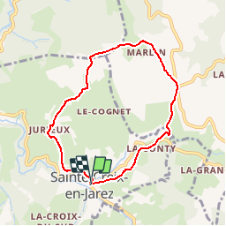

Length
7 km

Max alt
654 m

Uphill gradient
257 m
Km-Effort
10.4 km

Min alt
418 m

Downhill gradient
252 m
Boucle
Yes
Creation date :
2017-02-22 00:00:00.0
Updated on :
2020-01-04 20:29:26.163
2h14
Difficulty : Medium

FREE GPS app for hiking
 SityTrail
IGN / Geographical institutes
SityTrail Plus
The world is yours!
About
Trail Walking of 7 km to be discovered at Auvergne-Rhône-Alpes, Loire, Sainte-Croix-en-Jarez. This trail is proposed by trietsch.
Positioning
Country:
France
Region :
Auvergne-Rhône-Alpes
Department/Province :
Loire
Municipality :
Sainte-Croix-en-Jarez
Location:
Unknown
Start:(Dec)
Start:(UTM)
628736 ; 5037507 (31T) N.
Comments