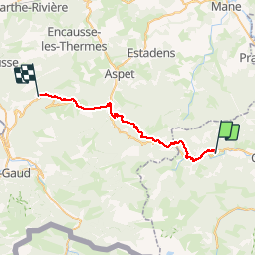
Trail Walking Orgibet - GR78 - Etape 8 Orgibet - Col des Ares - Photo

GR78 - Etape 8 Orgibet - Col des Ares

© OpenStreetMap contributors
Length
Length
32 km
Max alt
Max alt
1192 m
Uphill gradient
Uphill gradient
1466 m
Km-Effort
Km-Effort  
51 km
Min alt
Min alt
484 m
Downhill gradient
Downhill gradient
1322 m
Boucle
Boucle
No
Creation date :
2017-02-25 00:00:00.0
Updated on :
2017-02-25 00:00:00.0

(0 Reviews)

Walking
Walking
10h34
Difficulty : Difficult

Scan this QR Code to open this trail in the SityTrail application

FREE GPS app for hiking

Logo SityTrail SityTrail

IGN / Geographical institutes

Download SityTrail from the App Store Download SityTrail from Google Play

Logo SityTrail SityTrail World

The world is yours!

Download SityTrail from the App Store Download SityTrail from Google Play Download SityTrail on Huawei AppGallery

About

Trail Walking of 32 km to be discovered at Occitania, Ariège, Orgibet. This trail is proposed by patoche2009.

Description

Voir étape 1 Carcassonne - Ville neuve les Montréal

Elevation profile

Positioning

Country:
France
Region :
Occitania
Department/Province :
Ariège
Municipality :
Orgibet
Location:
Unknown
Start:(UTM)
331434 ; 4755492 (31T) N.

Trails nearby

Trail Walking Herran - 2020-08-20 Arbas -  cabane de roqué pic -  de paloumère - sommet de cornudère. - Photo
Walking
jacq58

Walking

Medium
Herran, Occitania, Haute-Garonne, France
13.2 km | 23 km-effort
4h 14min
Yes
Trail Walking Herran - Balade Coume Paloumere - Photo
Walking
Timax31

Walking

Very difficult
Herran, Occitania, Haute-Garonne, France
11.1 km | 19.5 km-effort
5h 6min
Yes
Trail On foot Salsein - Les crêtes de la Vallée du Biros - Photo
On foot
PRO

On foot

Easy
Salsein, Occitania, Ariège, France
10 km | 18 km-effort
4h 6min
No
Trail Mountain bike Herran - Espace VTT FFC Pyrénées Comminges - n° 33 La croix de Guéret  - Photo
Mountain bike
tracegps

Mountain bike

Very difficult
Herran, Occitania, Haute-Garonne, France
12.2 km | 21 km-effort
1h 45min
Yes
Trail Walking Herran - cap des Tèches depuis la Fontaine de l'ours  - Photo
Walking
GUIDE
lhomme.ph

Walking

Easy
Herran, Occitania, Haute-Garonne, France
7.2 km | 12.1 km-effort
3h 50min
Yes
Trail Walking Saint-Lary - stlary nereagreable - Photo
Walking
Bernard24

Walking

Medium
Saint-Lary, Occitania, Ariège, France
11.5 km | 19.5 km-effort
6h 4min
No
Trail Walking Aucazein - Chemin du piémont pyrénéen aucazein-Escabiros - Photo
Walking
dagobert5612

Walking

Very difficult
Aucazein, Occitania, Ariège, France
23 km | 36 km-effort
8h 46min
No
Trail Walking Orgibet - pic deserau - Photo
Walking
Bernard24

Walking

Very difficult
Orgibet, Occitania, Ariège, France
10.9 km | 22 km-effort
6h 21min
Yes
Trail Walking Orgibet - pic de Sérau depuis Orgibet  ( 2ème:07.05.2022) - Photo
Walking
chrisgps

Walking

Medium
Orgibet, Occitania, Ariège, France
10.1 km | 21 km-effort
6h 13min
Yes


Close
My subscriptions