


col de l'Arenier 07

ajd26
User
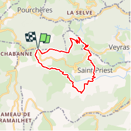

Length
12.7 km

Max alt
854 m

Uphill gradient
573 m
Km-Effort
20 km

Min alt
372 m

Downhill gradient
558 m
Boucle
Yes
Creation date :
2019-05-19 18:03:52.565
Updated on :
2019-05-19 18:03:52.756
4h15
Difficulty : Medium

FREE GPS app for hiking
 SityTrail
IGN / Geographical institutes
SityTrail Plus
The world is yours!
About
Trail Walking of 12.7 km to be discovered at Auvergne-Rhône-Alpes, Ardèche, Saint-Priest. This trail is proposed by ajd26.
Description
depuis le col de l'Arenier, parking à droite en venant de Privas, traversé la route pour le départ
Positioning
Country:
France
Region :
Auvergne-Rhône-Alpes
Department/Province :
Ardèche
Municipality :
Saint-Priest
Location:
Unknown
Start:(Dec)
Start:(UTM)
619460 ; 4953787 (31T) N.
Comments