


LE MOULIN BLEU

laoj
User
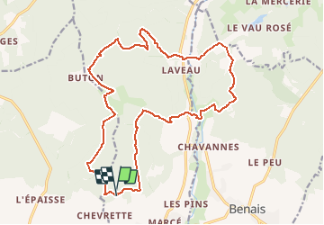

Length
21 km

Max alt
127 m

Uphill gradient
333 m
Km-Effort
25 km

Min alt
39 m

Downhill gradient
336 m
Boucle
Yes
Creation date :
2017-02-27 00:00:00.0
Updated on :
2017-02-27 00:00:00.0
1h39
Difficulty : Medium

FREE GPS app for hiking
 SityTrail
IGN / Geographical institutes
SityTrail Plus
The world is yours!
About
Trail Mountain bike of 21 km to be discovered at Centre-Loire Valley, Indre-et-Loire, Bourgueil. This trail is proposed by laoj.
Description
XCO dans le pays de Bourgueil
Départ et arrivée au restaurant le Moulin Bleu
Positioning
Country:
France
Region :
Centre-Loire Valley
Department/Province :
Indre-et-Loire
Municipality :
Bourgueil
Location:
Unknown
Start:(Dec)
Start:(UTM)
285588 ; 5242419 (31T) N.
Comments