Villepey rando réelle

Sugg
User
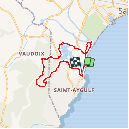

Length
14.8 km

Max alt
118 m

Uphill gradient
186 m
Km-Effort
17.3 km

Min alt
-1 m

Downhill gradient
186 m
Boucle
Yes
Creation date :
2019-03-22 16:58:45.662
Updated on :
2019-03-22 16:58:45.731
3h47
Difficulty : Easy

FREE GPS app for hiking
 SityTrail
IGN / Geographical institutes
SityTrail Plus
The world is yours!
About
Trail Walking of 14.8 km to be discovered at Provence-Alpes-Côte d'Azur, Var, Fréjus. This trail is proposed by Sugg.
Description
25 01 17 Rando RF
Photos

Positioning
Country:
France
Region :
Provence-Alpes-Côte d'Azur
Department/Province :
Var
Municipality :
Fréjus
Location:
Unknown
Start:(Dec)
Start:(UTM)
316010 ; 4807089 (32T) N.
Comments