


Tourtour-Fontigon 2

Sugg
User
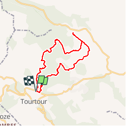

Length
16.6 km

Max alt
768 m

Uphill gradient
314 m
Km-Effort
21 km

Min alt
660 m

Downhill gradient
313 m
Boucle
Yes
Creation date :
2019-03-22 16:58:42.371
Updated on :
2019-03-22 16:58:42.453
5h51
Difficulty : Easy

FREE GPS app for hiking
 SityTrail
IGN / Geographical institutes
SityTrail Plus
The world is yours!
About
Trail Walking of 16.6 km to be discovered at Provence-Alpes-Côte d'Azur, Var, Tourtour. This trail is proposed by Sugg.
Positioning
Country:
France
Region :
Provence-Alpes-Côte d'Azur
Department/Province :
Var
Municipality :
Tourtour
Location:
Unknown
Start:(Dec)
Start:(UTM)
282398 ; 4830390 (32T) N.
Comments