


Etape(4)

Jean-Phi81
User
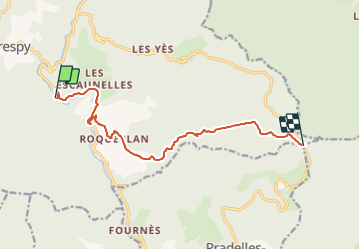

Length
11.3 km

Max alt
1153 m

Uphill gradient
647 m
Km-Effort
17.9 km

Min alt
532 m

Downhill gradient
32 m
Boucle
No
Creation date :
2017-02-28 00:00:00.0
Updated on :
2017-02-28 00:00:00.0
4h07
Difficulty : Unknown

FREE GPS app for hiking
 SityTrail
IGN / Geographical institutes
SityTrail Plus
The world is yours!
About
Trail Walking of 11.3 km to be discovered at Occitania, Tarn, Mazamet. This trail is proposed by Jean-Phi81.
Positioning
Country:
France
Region :
Occitania
Department/Province :
Tarn
Municipality :
Mazamet
Location:
Unknown
Start:(Dec)
Start:(UTM)
450156 ; 4810659 (31T) N.
Comments