


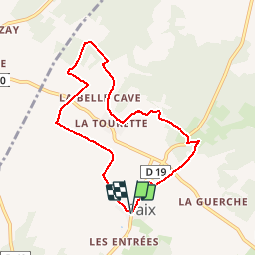
LE PR DE LA CROIX VERTE

laoj
User

Length
7.4 km

Max alt
100 m

Uphill gradient
109 m
Km-Effort
8.9 km

Min alt
46 m

Downhill gradient
108 m
Boucle
Yes
Creation date :
2017-02-28 00:00:00.0
Updated on :
2017-02-28 00:00:00.0
1h56
Difficulty : Medium

FREE GPS app for hiking
 SityTrail
IGN / Geographical institutes
SityTrail Plus
The world is yours!
About
Trail Walking of 7.4 km to be discovered at . This trail is proposed by laoj.
Description
Départ église de SAIX
Sanitaires à proximité.
passage à proximité du château de Pas de loup
Positioning
Country:
France
Region :
POITOU-CHARENTES
Department/Province :
VIENNE
Municipality :
SAIX
Location:
Unknown
Start:(Dec)
Start:(UTM)
727482 ; 5224754 (30T) N.
Comments